
Les Libres Géographes (The Free Geographers)
Francophonie and countries of the South // OpenStreetMap, free software and open data // training – field mapping – SDI // low cost – replicability // Geocommons
Since 2010, our collective has been mobilizing the principles, tools and practices of the OpenStreetMap (OSM) project, the free software movement and open data in the context of development aid or humanitarian action.
Our goal is to support the expansion of the OSM project in developing countries and least developed countries within the French-speaking world, to promote high-quality open geodata in these regions, and to build local capacity to create and use such data to produce the geographic commons necessary for harmonious territorial development.
Association of law 1901 since spring 2017, we work mainly from community empowerment devices of mostly young OSM contributors, coming from grassroots community organizations, university, co-working spaces, labs and technophile hubs or already active in government institutions, local or international NGOs or international organizations, so that they work together as a geomatics community.
Inspired by the commons movement, we make available open source collective tools and our pedagogical materials under free license.
Our Projects
Our Commons
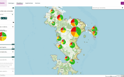
Free Francophone Spatial Data Infrastructure
A platform to support capacity building (training/self-training) and initiatives for sharing open geographic data in the Global South, in accordance with the practices and ethics of the OSM project, the free software and open data movement, and the principles of the community and/or the social economy.
OpenStreetMap ETL in English and French
To facilitate the reuse of OpenStreetMap data in French-speaking countries in the Global South, LLg has implemented an ETL (extract, transform, load) system within its IFL that allows users to download detailed OSM thematic layers for these countries, available both in their original English version and in a version automatically translated into French. These layers are continuously updated, with updates synchronized with the main OSM database every few minutes.
Guide to Open Geomatics and Open Data
A self-guided learning path that helps you connect with all stakeholders in the field of geomatics through the practices and resources of the OSM project and their reuse in cartography and geographic information systems (GIS).
Guide to Organizational Commons
An open-license organizational resource kit to support the launch and/or strengthening of associative and professional structures, particularly for individuals and groups active in the OSM project in French-speaking countries in the Global South.
Our News
OSM Mapping of Building Damage in Mayotte Following Chido: New Indicators and Initial Findings
Strengthening the Methodological Approach In my previous post about mapping building damage in...
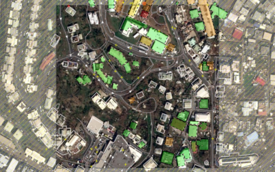
OSM mapping of building damage in Mayotte following Chido
OSM mapping of building damage in Mayotte after cyclone Chido On December 14, 2024, Mayotte was...

OSM data in English, but also in French, accessible in IFL for French-speaking countries in the South
Downloadable OSM data with attributes in a language other than English, not with a web service,...