
Creation of geographic data
Are you interested in mapping one or more regions on one or more topics with the goal of producing high-quality, freely accessible geographic data, while building or strengthening local capacity to replicate the methodology used?
Do you need a partner with expertise across the entire data lifecycle, experience in over twenty regions in the Global South, and a network of local experts who have previously been involved in similar projects?
LLg has extensive experience in implementing geographic data collection projects in the Global South, with the advantage of integrating them as much as possible into the OpenStreetMap technical and human ecosystem and its grassroots, community-driven approach.
LLg knows how to develop data models, create complex field survey forms, optimize the integration of collected data into OpenStreetMap, implement methods for monitoring and quality control as well as updates, and produce final domain-specific datasets shared according to standard exchange protocols. All while using low-cost approaches and open-source tools.
Whether mapping urban and rural areas on-site using imagery and field data collection, or coordinating remotely through its network of contacts, LLg systematically mobilizes groups of OSM mappers who will emerge from this experience strengthened both technically and organizationally. They will then be technically capable of continuing to create or update the data obtained.
Vector data on a variety of topics, at all spatial and temporal scales
- Expertise focused on vector geographic data (points, lines, polygons, and relational objects)
- Mapping of permanent or temporary spatial objects, provided they do not contain
- The ability to respond both in person as well as in a specific field within a short timeframe, as well as remotely across multiple regions over the long term
An open-source geomatics solution chosen based on specific needs and budget
- Based on a contextual assessment, within the constraints of a given budget and technical requirements
- By establishing a comprehensive data model and defining all stages of the data lifecycle (collection, storage and backup, processing, analysis, and dissemination)
- By systematically prioritizing open-source, low-cost, and simple technical solutions that have proven their robustness over time, in order to facilitate local adoption and replication
A solution that is as fully integrated as possible into the OpenStreetMap project
- Through pioneering work in implementing OpenStreetMap projects in the humanitarian and development sectors, from both technical and human perspectives
- By leveraging the richness and semantic flexibility of OpenStreetMap to adapt the data model, when the data is compatible with the OSM project
- By relying on tools from the OpenStreetMap ecosystem throughout the entire data lifecycle
Systematic involvement of local groups, which the project will strengthen
- For teams of any size, even those with very limited technical skills at the start of the project
- By relying on local OpenStreetMap communities, which have already been trained in the past—both technically and organizationally—by LLg members, or are known within its networks
- By promoting a workflow that turns local participants not just into surveyors, but into mappers and field coordinators who will be able to replicate the exercise within their own communities.
High-quality data that is accessible over the long term
- Always incorporating procedures and monitoring tools to ensure data quality.
- Ensuring their long-term preservation and accessibility through OpenStreetMap and the Francophone Open Source IDS (IFL) based on geOrchestra
- Also enabling their use through thematic applications, dashboards, or geostories
Implementation examples
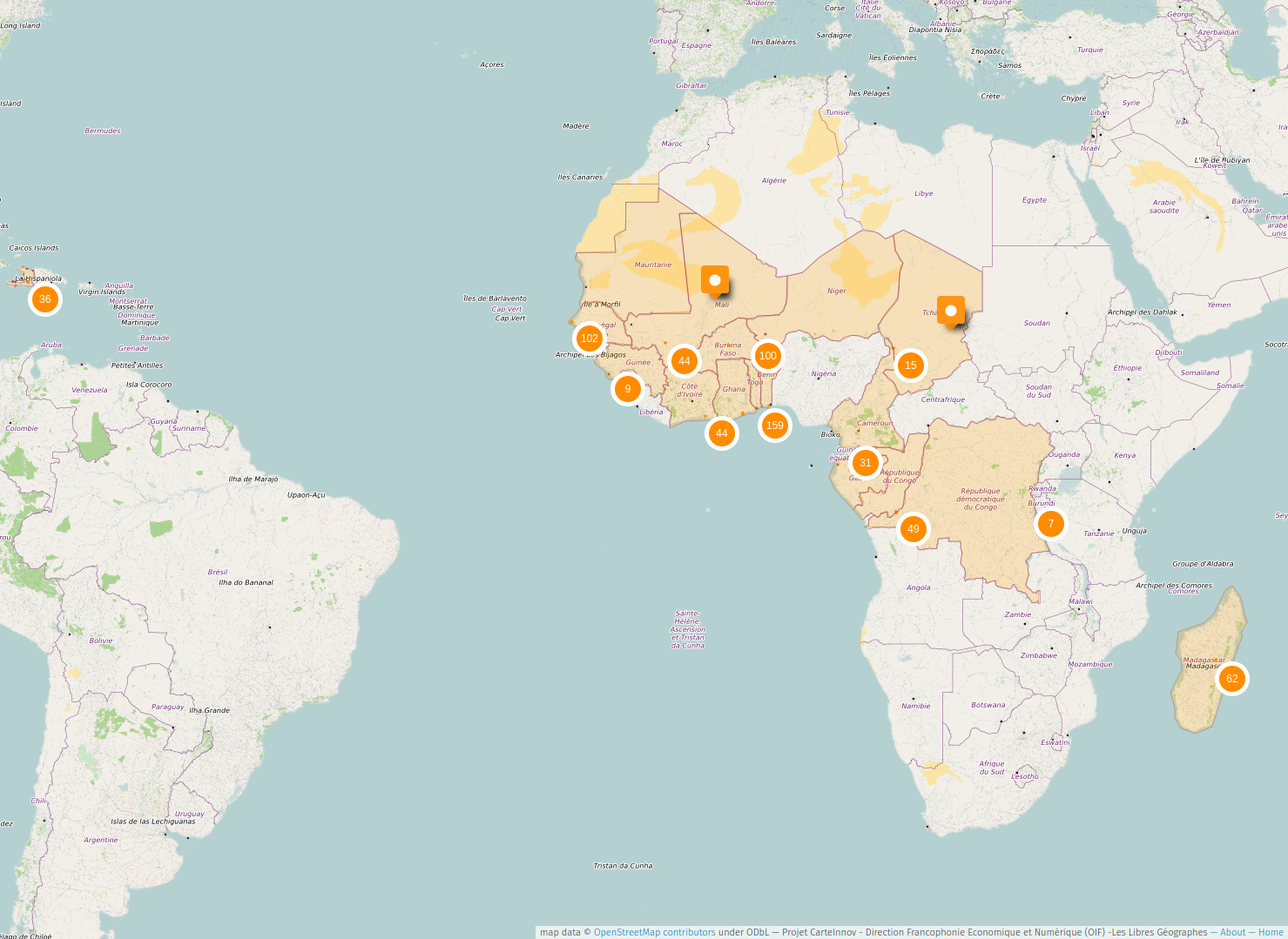
Remote-sensing-based thematic mapping across 20 countries
CarteInnov, a map of digital innovation locations in nearly 20 French-speaking countries in the Global South, stored in OpenStreetMap, with remote coordination of data collection and local outreach efforts carried out by members of local OSM collectives.
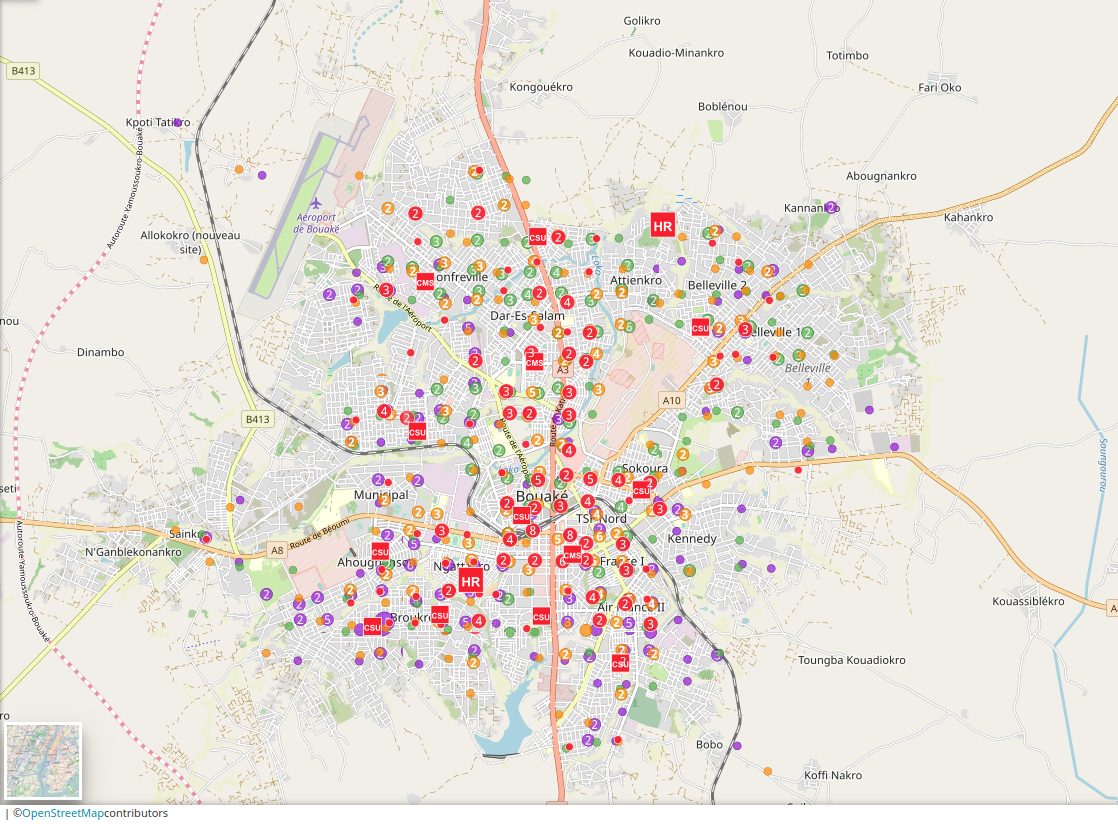
Multi-thematic mapping of an urban area from a research/monitoring perspective
COheSiON, a four-year multidisciplinary project in which LLg organized multi-thematic mapping (health, education, places of worship, government offices, markets, and community water points) of Bouaké, the second-largest city in Ivory Coast, using satellite imagery and field surveys on themes detailed in their attributes using a data model and tools adapted for integration into OpenStreetMap. By involving members of the OSM community in Ivory Coast and students from Bouaké.

Diagnostic et refonte des outils de collecte et d'exploitation de données d'un programme national
Dans le cadre du projet Trypa-NO! mené par le Plan National de Lutte contre la THA, une analyse des besoins de l’équipe Lutte Anti-Vectorielle et la mise en place de moyens de collecte centrés à la fois sur KoBoToolbox et les applications OSM selon le type de données métier collectées, accessibles et diffusées via IDS (Infrastructure de Données Spatiales).
Cartographie détaillée de quartiers urbains pour établir un pré-diagnostic urbain communautaire
Sunu Gox, une approche originale de pré-diagnostic territorial mené en partenariat avec le Gret et Y en a Marre (YAM) dans des communes populaires de Dakar au Sénégal et réalisé avec des membres des organisations de base de quartiers concernés par les futurs aménagements du projet. Les données ont été collectées à travers une formation aux outils OSM suivie d’une phase de cartographie de terrain.